Dr. Annett Bartsch.
Dr. Annett Bartsch is the founder and director of b.geos, an organization focused on developing Earth Observation services and providing access and training for remote sensing technologies and applications.
Highlight: “Being able to build a team and work on projects which provide an international framework
has facilitated the most exciting research achievements.” – Dr. Annett Bartsch.
Dr. Bartsch is a geographer who had the chance to learn about Arctic issues during her studies. More specifically, her interest in Arctic research was sparked by conducting field work and spending time at a research station.
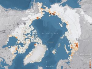
A map of communities affected by permafrost loss. PC: https://climate.esa.int/fr/actualit%C3%A9s-et-des-%C3%A9v%C3%A9nements/satellites-identify-communities-at-risk-of-permafrost-thaw.
Although satellites are incredibly useful and can provide spatially-consistent information, there are challenges associated with using the data output. Dr. Bartsch’s main research interest involves “using satellite observations to get a complete picture of the current status of the Arctic land area and to capture and understand changes”.
Bartsch and her team are working on technical solutions while collaborating with scientists across disciplines to analyze the human footprint and environmental changes linked to the carbon cycle across the Arctic.
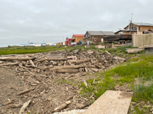
Houses in Tuktoyaktuk, Canada. PC: Dr. Annett Bartsch.
Their latest Arctic Data Center (ADC) dataset titled Arctic Infrastructure: Sentinel-1 and Sentinel-2 derived Arctic Coastal Human Impact dataset, Pan-Arctic Region, 2016 – 2020, part of the HORIZON2020 (H2020) Nunataryuk and ESA Polar Cluster EO4PAC projects, focuses on using Copernicus Sentinel-1 and Sentinel-2 derived data to detect coastal infrastructure and communities affected by permafrost thaw and serves as an update to previous datasets. The dataset includes coastal infrastructure categories such as asphalt, gravel, undefined linear transport infrastructure, buildings and bridges, gravel pads, mining sites, airstrips, and reservoirs or other water bodies which are impacted by human activities.
This dataset combines different types of sensors and machine learning techniques that vary in their advantages and disadvantages. Satellite data provides information from the ground that is then combined with other results to produce a fully interpretative and useful dataset. Dr. Bartsch emphasizes that “regular, consistent coverage by freely available satellite data is crucial for Arctic monitoring. Efficient data analysis has become key to many aspects of our research and lives in general,
but to exploit these capabilities we need the right data as input.”
A large part of developing this dataset and successful science includes international collaboration with scientists of varying disciplines that drive research and technical development. Dr. Bartsch explains that the H2020 project Nunataryuk, led by AWI, has brought together a wide range of scientists who share an interest in Arctic coastal issues. Current information on where Arctic communities are located is necessary to facilitate studies focused on the impact of climate change in sensitive regions. Satellite data has allowed researchers to identify the human footprint from space, keeping in mind that this can only provide a fraction of the full picture.
In the future, Dr. Bartsch hopes for regular, consistent coverage by freely available satellite data, as this is crucial for Arctic monitoring. She notes that efficient data analysis has become key to many aspects of Arctic research and communities, but the right input data is needed to exploit these capabilities.
When asked about her experience with the ADC, Dr. Bartsch stated that the data repository is important for the visibility of research across the Arctic and as a hub of data exchange among scientists.
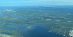
Inuvik, Canada. PC: Dr. Annett Bartsch.
Citation: Arctic Infrastructure: Sentinel-1 and Sentinel-2 derived Arctic Coastal Human Impact dataset, Pan-Arctic Region, 2016 – 2020. Arctic Data Center. doi:10.18739/A21J97929.
Written by Nicole Greco
Community Engagement and Outreach Coordinator, Arctic Data Center