Background
Born and raised in New England, Elias Manos was not familiar with the Arctic, but he had a deep interest in learning about this unfamiliar place. His academic background in geography more commonly dealt with geospatial data science, particularly analyzing satellite/aerial imagery with machine learning. While Manos was still an undergraduate, he began collaborating with Dr. Chandi Witharana, who was then focusing on developing deep learning models to analyze high-resolution satellite imagery of the Arctic. It was through this collaboration where Manos’ academic trajectory changed.
Funded by the National Science Foundation, the Navigating the New Arctic program has focused on innovative and interdisciplinary research that merges a wide array of sciences like computing and information science to address the connections between natural and built environments and deepen our understanding of Arctic change both locally and globally. To learn more about the program, please read their objectives on the NSF official website. This funding has paved the way for the Permafrost Discovery Gateway (PDG) project to make information about permafrost more accessible and discoverable by the public.
Over the last few years, Manos has helped to develop deep learning models and high-resolution geospatial datasets for the PDG project alongside Witharana and many other collaborators like the Arctic Data Center. This high-value work as Manos describes it, “is helping improve our understanding of how the Arctic is [continuously] transforming.”
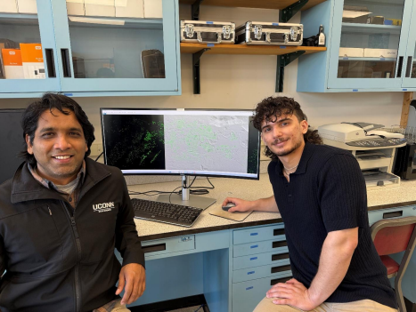
Dr. Chandi Witharana (left) and PhD student Elias Manos (right) of the University of Connecticut Department of Natural Resources & Environment.
Research Interests
Manos explains that disaster risk stems from interactions of hazards with exposed assets such as people infrastructure, environmental resources, cultural sites, etc., and can be exacerbated by socioeconomic vulnerability. He points out that publicly available geospatial data on pan-Arctic infrastructure is limited both in geographic coverage and attribute information. This lack of data poses a challenge for accurately estimating the cost of damages associated with permafrost thaw, which is what Manos’ and his collaborators aim to address.
By filling these data gaps with state-of-the-art deep learning models, scientists, community members, and decision-makers will be better equipped to assess disaster risk from permafrost thaw as the model would automatically detect buildings from high resolution satellite imagery. By having this model focus on Alaska, it will eventually support a pan-Arctic permafrost thaw disaster risk model for other communities to adopt. Such tools could help communities strengthen their hazard mitigation plans, and as Manos notes, “demonstrate the risk they face from permafrost thaw and the cost-to-benefit ratio of implementing adaptation strategies [which] are often prerequisites for securing government assistance.”
Dataset Highlight
The PDG project brings together a diverse group of remote sensing scientists, computer scientists, hydrologists, permafrost researchers, and community leaders working toward a common goal: making permafrost data more accessible and discoverable to the public. They produce and provide large geospatial datasets and notably released the first pan-Arctic geospatial map of ice-wedge polygons. Their detection algorithm used to extract these landforms from satellite imagery was developed in close collaboration with experts who are familiar with permafrost geomorphology.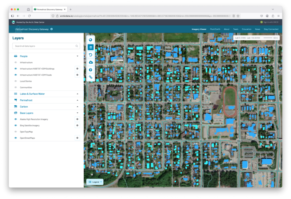
This dataset includes a comprehensive inventory of Alaskan buildings, storage tanks, and roads that were (1) detected from a 0.5 meter resolution satellite imagery of 285 communities between 2018-2023 and (2) supplemented by OpenStreetMap data. The team created a high-resolution Arctic built infrastructure and terrain analysis tool otherwise known as HABITAT, which is a deep learning-based, high performance computing-enabled mapping pipeline to automatically detect buildings and roads from high-resolution Maxar satellite imagery across the Arctic region.
Using this deep learning model, their team was able to expand their OpenStreetMap building footprint and was able to determine that permafrost thaw will run the risk of increased hazards. Their analysis estimated that building and road losses could cost Alaska about $37B to $51B in damages. On the PDG portal, you can see the data layer for the OpenStreetMap data collected by the team.
As part of this research, Manos and collaborators published the following dataset:
- Elias Manos. (2024). Comprehensive baseline inventory of Alaskan buildings and roads detected from 0.5 meter resolution satellite imagery (2018-2023) of communities and supplemented by OpenStreetMap. Arctic Data Center. doi:10.18739/A2KS6J64W.
In addition, this dataset garnered significant interest from the science community and was the recent focus of a published paper in Nature Communications Earth & Environment:
- Manos, E., Witharana, C. & Liljedahl, A.K. Permafrost thaw-related infrastructure damage costs in Alaska are projected to double under medium and high emission scenarios. Commun Earth Environ 6, 221 (2025). https://doi.org/10.1038/s43247-025-02191-7
More relevant datasets are available at the end of this blog.
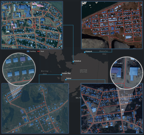
Each panel (and two zoom-ins) shows delineations of buildings, roads, and storage tanks predicted by the infrastructure detection model from Maxar satellite imagery of four different Alaskan communities (Utqiagvik, Kotzebue, Hooper Bay, and Bethel). Credits: Imagery: © Maxar, Inc.
Methods & Technology
A significant amount of computing hours went into the creation and curation of this dataset. A convolutional neural network (CNN) was used to generate a comprehensive baseline inventory of Alaskan buildings and roads detected from a 0.5 meter resolution satellite imagery. CNNs are a large collection of mathematical transformations that are trained to extract visual patterns in imagery at different resolutions that are representative of objects of interest. They are regarded as a state-of-the-art tool in high-resolution satellite imagery analysis.
Manos used a CNN based on the “UNet+++” architecture, originating from a 2015 “UNet” architecture that has been popularly used over the last decade. For six months, Manos manually outlined 10,000 building and road segments from 20 different Maxar satellite images acquired over Arctic communities in Alaska, Russia, and Canada to help train the model.
Highlighting the Impacts of a Changing Arctic Through Research
Arctic communities are disproportionately affected by the adverse impacts of a changing climate. Despite being the least responsible for global emissions, they are often the first to feel its consequences through permafrost thaw, infrastructure damage, and daily life disruptions.
International climate finance mechanisms are designed to support the most vulnerable to climate change impacts, yet Arctic communities get overlooked despite sharing similar vulnerabilities. Why? Many Arctic communities exist within the borders of comparatively developed and wealthy countries, therefore, desperately needed assistance is diverted away. Manos urges decision makers to prioritize the potential loss and damage Arctic communities will face if not appropriately addressed. To learn more, he points to this article by the World Wildlife Fund which further dives into the topic.
That’s what makes the work by Manos and his collaborators on the PDG so crucial. By developing an improved pan-Arctic permafrost thaw disaster risk model coupled with socioeconomic vulnerability data, the magnitude of disaster risks the Arctic is set to face is undeniable.
Manos notes the most rewarding aspect of his involvement with Arctic research has been his contribution, even if small, in tackling such a monumental issue. One that not only affects communities today, but will shape the future of generations to come.
The future of Arctic Research
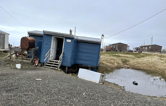
A home in Point Lay, Alaska that is affected by thawing permafrost Photo credits: Benjamin Jones.
The development of open knowledge platforms like the PDG represents key innovations for adaptation and resilience in Arctic research. Manos emphasizes the importance of expanding geospatial products to create support tools for decision-making for Arctic communities that could help with responses to various natural and anthropogenic hazards. As he explains, “[this could help them choose] the best course of action based on the output of analyses that combine the best available high-resolution geospatial data.”
Similarly, the Interagency Arctic Research Policy Committee’s (IARPC) 2022-2026 Arctic Research Plan points to risk management and hazard mitigation as one of their four priorities. Advancing this goal would require more high-resolution circumpolar geospatial data products to support their efforts and help plan the future of the Arctic. Manos points out that a high resolution circumpolar dataset of observed and/or predicted ground ice content could be monumental in advancing the mapping of thaw hazards and help decision-making regarding hazard mitigation. He encourages those unfamiliar with the impacts of permafrost degradation on infrastructure to review this paper from Nature Reviews Earth & Environment.
How is the Arctic Data Center useful for researchers?
Manos has worked closely with the ADC for a few years and has gained a great appreciation for the behind the scenes work of everyone involved in the project, which has helped the PDG to continuously improve. As Manos puts it, “The Arctic Data Center gets all the credit for making my geospatial data products publicly-available and accessible to a wide audience, and even visualizing the data on the Permafrost Discovery Gateway. They manage datasets from countless other scientists, which I’m sure is a monumental task, but it’s a task needed to maintain the scientific process.”
As a young scientist and current student, Manos encourages those unfamiliar with the Arctic to learn more about the region and be curious about institutions with professors who have funding to conduct Arctic research.
Other Relevant Datasets:
- Elias Manos. (2024). Comprehensive baseline inventory of Alaskan buildings and roads detected from 0.5 meter resolution satellite imagery (2018-2023) of communities and supplemented by OpenStreetMap. Arctic Data Center. doi:10.18739/A2KS6J64W.
- Elias Manos, Anna Liljedahl, & Chandi Witharana. (2024). Ice Wedge Network Centerline and Ice-Wedge Polygon Coverage in the Bernard River Watershed, Banks Island Canada; 2010-2020. Arctic Data Center. doi:10.18739/A2610VT6C.
- Chandi Witharana, Mahendra R. Udawalpola, Amal S. Perera, Amit Hasan, Elias Manos, Anna Liljedahl, Mikhail Kanevskiy, M. Torre Jorgenson, Ronald Daanen, Benjamin Jones, Howard Epstein, Matthew B. Jones, Robyn Thiessen-bock, Juliet Cohen, & Kastan Day. (2023). Ice-wedge polygon detection in satellite imagery from pan-Arctic regions, Permafrost Discovery Gateway, 2001-2021. Arctic Data Center. doi:10.18739/A2KW57K57.
- Elias Manos. (2022). Utqiagvik, Alaska built infrastructure (buildings and roads) 2002 and 2014 (<1 meter resolution). Arctic Data Center. doi:10.18739/A2B27PS5M.
Written by Angie Garcia
Community Engagement and Outreach Coordinator, Arctic Data Center